I've posted the slides from a presentation I gave at the
Dimensions of Political Ecology conference here at the University of Kentucky recently. My argument is pretty straightforward: to have an ecosystem service, like wetland water storage and delay, you have to be able to show where it that service exists in the landscape and software tools like Excel, ArcGIS, and online mapping utilities are really fundamental to that calculation. It's kind of like the old thought experiment - if a tree falls in the forest and no one's around to hear it, does it make a sound? Does a wetland provide a flood mitigation service if it is in the middle of nowhere? I don't mean to get all philosophical on you, but the basic point is that ecosystem services - as valuable benefits of nature to society - might not exist as such if environmental agencies and others weren't able to map where they exist and who they benefit. So, the talk is a modest call to pay attention to regulatory, entrepreneurial, and conservationist exercises in mapping services, like
InVEST from the Natural Capital Project. I've pasted the text of the talk below; each paragraph corresponds with one slide.
1. Ok, so I promise you that this picture of people idling in line to get tickets at the Portland airport is relevant to what I really want to talk to you about today: market valuation of ecosystem services. I’m going to show that airport terminals, in fact share a lot in common with the restoration sites through which Oregon conservationists and entrepreneurs value ecosystem services for market. I make two calls in my talk: 1, for ecosystem services researchers to pay attention to spatially explicit ECS valuation, and to ask for whom such valuations work. 2, to call upon political ecologists to keep paying attention to spatial visualization techniques, but to also pay attention to other technologies through which spaces – like airport terminals, and restoration sites - are made and valued.
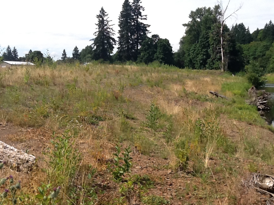
2. Welcome to the Half Mile Lane site in exurban Portland, Oregon. It provides a number of ECS. The wetland you see stores and delays water, which mitigates flood impacts for downstream homes. The stream, which you can’t really see, provides habitat for salmon that migrate into the foothills of the Coast Range. A couple of years ago, state environmental agencies and conservationists undertook ecological restoration on the site, turning old farmland and a straightened ditch into a productive wetland and stream.
3.That these services exist as services is spatially dependent, or contextual. I’ll give you three quick quotes to show how. As you see here, the international think-tank for ecosystem services accounting, TEEB, note that you have to have a specific site to have a service. The work of the wetland at HML to store and delay water matters only because there are homes in the 100 year floodplain downstream of the site that benefit.
4. Long-time ECS researcher Gretchen Daily concurs. She calls for focusing on the right places in the landscape. HML’s position, for instance, allows it to slow down and cycle the increased runoff from logging operations.
5.Finally, lest you think this focus on landscapes is the domain solely of pundits like TEEB and Daily, consider what the Oregon DSL has to say. One phrase we often hear in the ECS world – we did in the TEEB quote - is “value of nature”. What does value mean? For DSL, it means the opportunity to provide an ecological function. Crucially, this opportunity is location-based.
6. Now, DSL oversees wetland and stream ECS markets in OR. The way these markets work is entrepreneurs restore ECS on sites like HML and sell the ecological benefit they create, as a credit commodity, to housing developers, DOTs, and others that are paving over wetlands and streams in different parts of the watershed. In fact, HML here is one such mitigation “bank” of restoration credits. There many different kinds of actors in the market. You’ve got state agencies like DSL with statutory obligations and ecological inclinations, but also NGO groups with conservation missions, and of course entrepreneurs looking to do banking for profit. This raises a key question: to what extent do market-makers account for context, or value? Or for them, is a service just a service, no matter where it’s provided? How do market actors decide where it is most ecologically valuable to do restoration?
7. What I want to show in the rest of the talk are three things:
1. Digital tools like Excel and GIS allow the OR market to account for context
2. However, these tools and the algorithms that underwrite them are not mirrors of nature. Rather, tools reflect the interests of market actors
3. In Oregon, state agencies and conservationists may have the upper hand in defining and accounting for ECS values.
I make these arguments by outlining three moments in which value is accounted for in OR’s markets. I end by putting out a couple of calls for future research.
8.I’ll tell you first about the assessment moment of ecosystem services valuation in Oregon’s wetland and stream markets. Entrepreneurs hire consultants to do a key part of the work of the market: assess restoration success. In assessment, consultants utilize Excel spreadsheet-based calculators of ecological process. One of these calculators is called the Oregon Rapid Wetlands Assessment Protocol, or ORWAP. There are ones for salmon habitat, water temperature, and other services, but they’re all conceptually very similar, so I’ll focus on ORWAP. Most of them were in fact written by the same person, under contract from DSL and US EPA. He’s been developing these assessments for about 30 years now, which is when he first made a split in assessing ecological process or function, and value.
9.Consultants score functions in ORWAP through a series of multiple choice questions about things like seasonal surface water extent.
10. Consultants also do work in the office, employing several online mapping tools for an assessment of value. Here’s one called Oregon Explorer. Hydric soils are the orange/yellow, but we also see the 100 year floodplain downstream of the site. OR Explorer knows, too, about rare species on the site. It’s bringing a lot of data from beyond the boundaries of the site together, and showing it to the user in one frame. The user can thus answer questions in ORWAP about landscape context by using OE to, for instance, draw a 2 mile radius circle around the site to see how many other similar habitats the site is connected to in the area.
11. What offsite stressors, and risks consultants find in their assessment, regulators can consider in approving or denying a banker’s plan. For instance, regulators often focus on reed canary grass, an invasive species that can spread rapidly on a restoration site from without and foil the project. They question whether a site and its landscape surroundings will, in the end, prove valuable if there is too much RCG around. Theoretically environmental agencies can in this moment deny a banker’s proposal to work on a certain piece of ground that is particularly susceptible to weeds. In reality, however, they are more likely to just modify the banker’s site selection, perhaps by asking them to put more money into a long-term management.
12. Finally, there is a market moment to value’s measure. What conservationists want to see happen in the market is that when a banker brings a site to the market, to get their credits to sell, the amount they get depends in large part on the location of their project. They would get the full amount if they were in what’s called a priority area and less if they were not.
13. These areas are an aggregation of habitat sites mapped by state environmental agencies, and put together by TNC. To be clear: this isn’t how the market currently works, but regulators do use GIS to look at whether bankers are siting in priority areas, and conservationists are pushing for this trading ratio protocol to be adopted.
14. The problem is that if a banker had to do work in a priority area lest they not get as many credits as expected, that could be at least a short-term constraint to the market, especially if land prices in priority areas were higher. In general, through all these moments, how state agencies, with help from conservationists, want to assess value via site selection, will constrain entrepreneurs. At the same time, agencies and conservationists are not now fully determining site selection. Rather, the maps they make give them something to point to and say, bankers should go here rather than there. Or, in other cases, spreadsheets like ORWAP in tandem with maps let them say, look there’s a quarry upstream, don’t go there.
15. The state and conservationists will want these gestures to be assertive. What underwrites their ability to point to a map in the first place? In large part, code. I want to turn quickly to work in information technology studies as a way of understanding valuation in OR. Recently, geographers Rob Kitchin and Martin Dodge wrote a book called Code/Space in which they argued that spaces are increasingly constituted by computer code. An airport terminal is only the kind of space it is if the 0s and 1s that run the check-in stations work; when they crash, the space turns from a hub of international commerce into a den of frustration. In the same way, a restoration site or classes of ecosystems cannot be priority spaces if the software that codes them that way does not work the way it is supposed to. In OR, the ability of ArcGIS to display and combine layers is crucial because layers allow for combining different ecological interests into priorities. Code underwrites how web mapping utilities aggregate different data and draw circles around it as well, allowing foroffsite visualization and valorization. And ORWAP can’t generate a value score without Excel’s ability to run calculations across so many different variables. The state/conservationists’ position is code-dependent.
16.So to wrap-up: Yes, markets in ecosystem services restoration, at least in OR, do have a spatial calculus of value, as TEBB and Gretchen Daily hope for. State agencies and conservationists work to make the calculation their own, and deploy it to their own ends. But it remains unclear how successful they can be. Their ability to write the code and utilizing the tools with which they see value in space will be crucial to their future market-making work.
17. And valuation tools will be worthwhile pay attention in other markets as well, as decision-makers continue to call for the price valuation and marketization of ECS. So ECS researchers should continue looking at the work of spatially explicit valuation, but ask, as Norgaard did, for whom does ECS governance work for? Conservationists? Regulators? Bankers? … Landowners? PEists are indeed well equipped to talk about winners and losers. But this is also a call to PEists to keep looking at code. We’ve looked at spatial visualization technologies before, but need to continue, and to look at code not just in GIS but in Excel and other programs. We can do this in partnership with scholars of the geoweb.